Tacoma has taken another step in its land use reform process to equitably house people and undo a legacy of exclusionary zoning. Home In Tacoma — an equitable affordable housing strategy — advanced beyond the Tacoma Planning Commission last week on a 6-3 vote in favor of recommendation. A chief piece of the recommendation is a deep revision to the future land use map — an element of the city’s comprehensive plan — affecting single-family and multifamily zoned areas of the city.
The commission also recommended that the Home In Tacoma project be phased in two parts, slowing down the timeline a bit and making the reforms more digestible. Under the phased approach, comprehensive plan changes and some near-term land use code and programmatic changes would be adopted in the first phase. Deeper land use code policies and zoning changes would follow in the second phase.
The planning commission’s recommended map revisions are essentially a hybrid of two map alternatives shared with the public in March and April. The recommended map would still direct land use and zoning changes for all areas zoned single-family and multifamily in Tacoma (all other zoned and designated areas are excluded from changes). If adopted, this would essentially end the concept of single-family zones in the city in both name and regulation. Single-family areas would be redesignated and rezoned to Low-Scale Residential or Mid-Scale Residential zoning types, which would permit a mix of housing types like duplexes, rowhouses, and apartments. Low-Density Multifamily areas would also get a boost to Mid-Scale Residential, a more intensive land use designation than the current one.
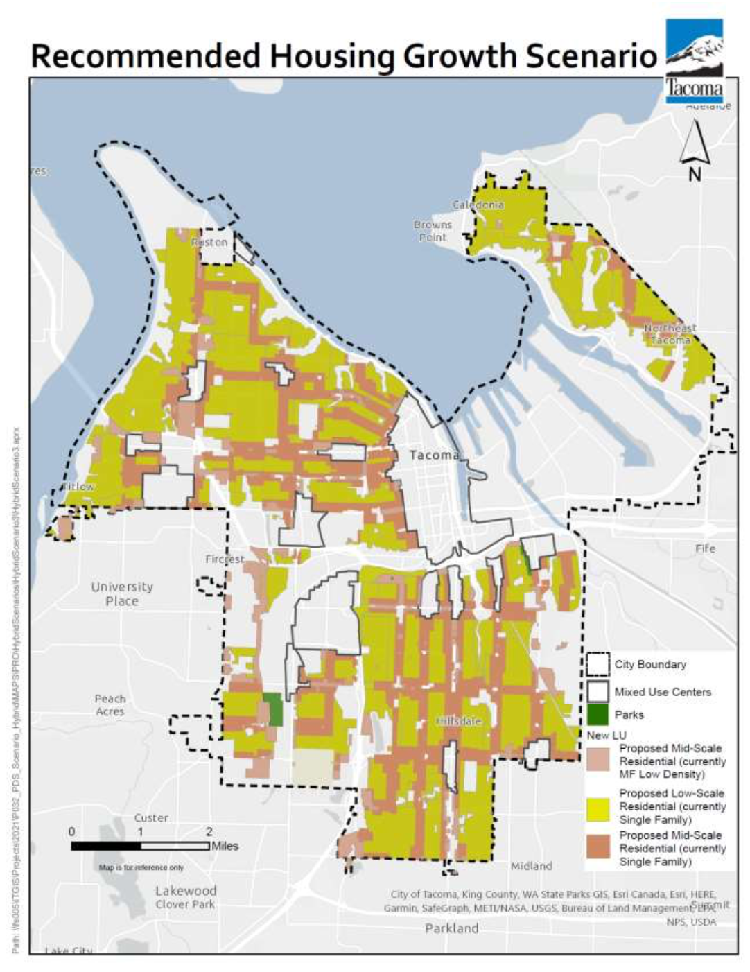
The planning commission received extensive feedback on the initial map alternatives released in March with about 900 comment submissions. Responding to this, the planning commission wanted to refocus the most intensive map changes within one to two blocks around neighborhood centers, transit corridors, and other main corridors. The commission toyed with several hybrid alternatives before settling on the recommended map last week. As a result, the recommended map generally connects Mid-Scale Residential areas by way of main corridors in a grid-like fashion. In between, Low-Scale Residential predominates as the primary land use designation. Overall, this shakes out as something like 65% Low-Scale Residential and 35% Mid-Scale Residential.