Washington State’s redistricting process is off to the most contentious start in 40 years as Republicans propose aggressive gerrymanders of Seattle and the state as a whole.
A major battle is unfolding over redistricting in Washington State, one that could wind up in the courts for the first time in 40 years. With a deadline of November 15 to draw new maps, the coming weeks may be decisive for the future of Seattle and the state as a whole.
Republican commissioners, fueled by the same no-holds-barred radicalism witnessed by their fellow party members in other states and in Congress, have proposed extreme gerrymanders of the legislative and Congressional districts. Their maps are designed to favor their party at the expense of racial justice and voter choice, as well as to undermine Seattle and our ability to have our urban needs met.
Because Republicans have equal representation on the redistricting commission, they have leverage that could force Democrats to cut a bad deal in order to get maps approved – unless Democrats are willing to throw it to the Washington State Supreme Court.
How the process works
After court battles in the 1970s and 1980s, state legislators created a temporary bipartisan commission to draw legislative and Congressional maps. They then proposed a constitutional amendment (SJR 103) that voters approved in the 1983 election to make the process permanent. A minor revision in 2016 created the current language in the state constitution. Each legislative caucus — House and Senate Democrats, House and Senate Republicans — appoints a commissioner, leading to four members of the commission, along with a nonvoting chair chosen by the other four commissioners.
Both parties are guaranteed equal representation on the commission, even if one party has not actually earned it at the ballot box. At least three members of the commission must vote to approve a final map, which means that Republicans hold veto power over redistricting in our state. If no map can win three votes, the state supreme court will draw the maps. The legislature can make changes to the commission’s approved maps but only by a 2/3 vote.
Like the filibuster in the U.S. Senate, the rules governing the commission have the potential to cause enormous problems if one of the parties chooses to pursue an extremist political strategy that eschews cooperation, as the Republican Party has done across America. In recent years we have seen Republicans upend traditional norms and refuse to make reasonable deals, preferring to instead demand Democrats accept unreasonable demands in order for government to operate.
In 2011, Republicans demanded and won a favorable legislative district map in exchange for agreeing to draw Washington’s new 10th Congressional district favorably for Democrats. Republicans used that map to erode Democratic numbers between 2012 and 2016, before the state’s electorate grew bluer again.
This time around, the Democratic commissioners are April Sims, Secretary-Treasurer of the Washington State Labor Council and appointed by the House Democrats, and Brady Piñero Walkinshaw, a former state representative from the 43rd LD and appointed by the Senate Democrats.
The Republican commissioners are Paul Graves and Joe Fain, who both lost their seats in the state legislature in 2018 in King County districts that had been drawn in 2011 to favor Republicans. Fain was accused of rape in 2018, and has refused to resign from the commission even after an outpouring of community demands that he not serve.
Proposed Democratic legislative district maps
The Urbanist’s Doug Trumm provided a good overview of the legislative maps proposed by the two Democratic commissioners. Redistricting Justice for Washington and the Washington Community Alliance have also shared their analysis, including their priorities for the Yakima Valley and Snohomish County Legislative Districts (LDs). This article will focus on the impact to Seattle, and look more broadly at how the overall process may unfold.
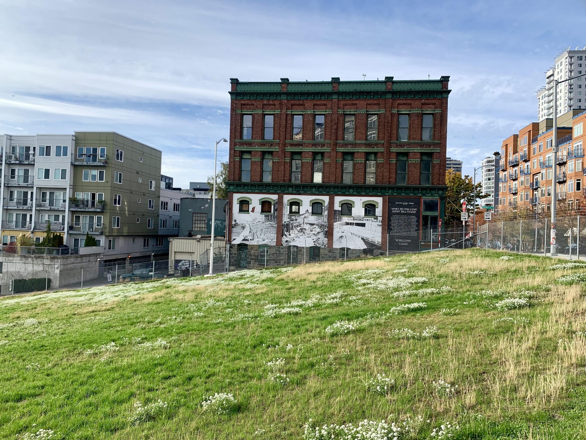
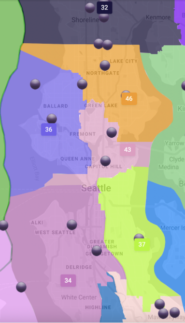
The Democratic commissioners’ legislative district maps would not have major changes to Seattle’s legislative districts. Both Sims’s map and Piñero Walkinshaw’s map would bring the 46th LD entirely into Seattle, and would substantially bring the 37th into Seattle. The 36th LD has to shrink, and both propose moving Belltown into the 43rd to help achieve that.
Exhibit 1: April Sims’ proposed map of Seattle legislative districts
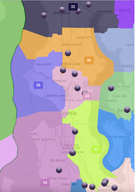
Sims’ map gives almost all of the 36th’s current territory north of 85th street (except for portions of Greenwood) to the 46th, whereas Walkinshaw’s does not. Walkinshaw includes more of Burien in the 34th LD by moving Vashon Island to the 26th LD, whereas Sims does not.
Exhibit 2: Brady Piñero Walkinshaw’s proposed map of Seattle legislative districts
Proposed Republican legislative district maps
The Republican commissioners’ maps, however, represent a clearly anti-urban effort to impose a radical gerrymander onto Seattle. Both Graves’ map and Fain’s map draw Bainbridge Island into Seattle LDs. While this wouldn’t likely change the partisan outcome of such a district, it would undermine communities of interest. Bainbridge’s concerns match the rest of Kitsap County — ferry dependent, less dense — and have little in common with the needs of the largest city in Cascadia.
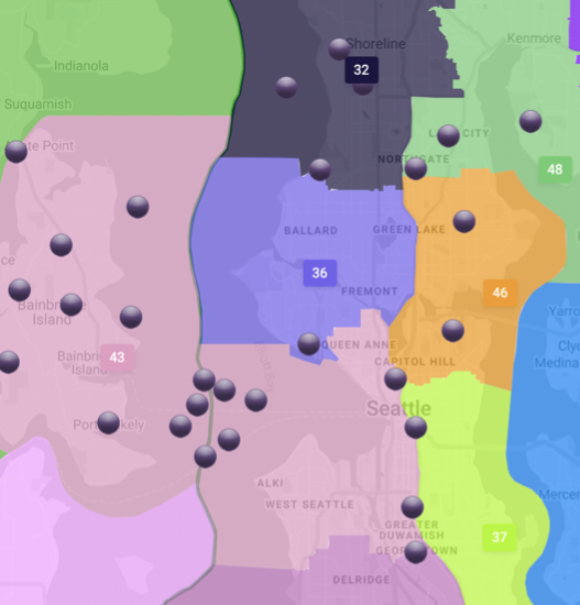
Graves’ map would dilute representation by placing neighborhoods with high proportions of people of color in the Northgate-Lake City area into a district mostly anchored in Kirkland, and cuts the Delridge corridor in half.
Both Graves and Fain would cut Chinatown/International District in half along Interstate 5, significantly harming that community’s ability to represent itself in Olympia.
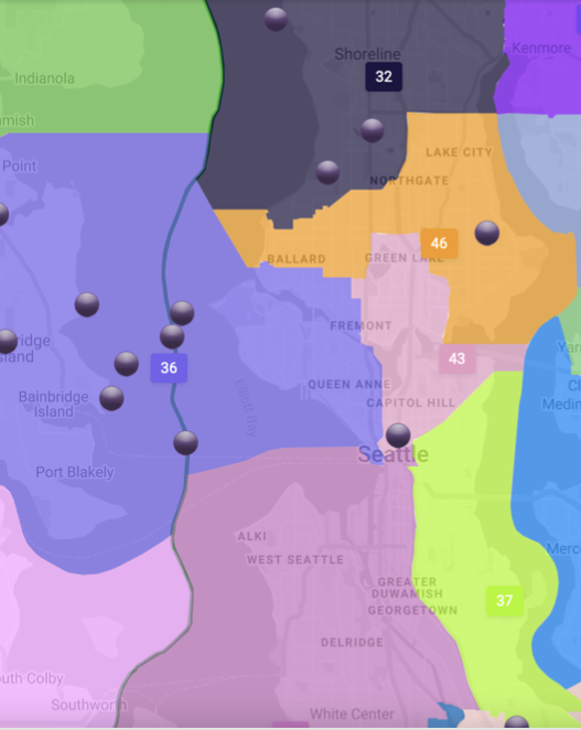
Fain’s map represents an even more aggressive gerrymander of Seattle, as if he has it out for the 36th LD in particular. He would chop up the 36th and put it into four different LDs, cutting Ballard in half and putting its dense core in the same LD as Magnolia, Queen Anne, and Bainbridge Island.